Simulating climate response to increased urban land fraction using CLM5 in CESM 2.1.5
Course: Earth System Modelling
George Mason University
Land Component of Community Earth System Model
Abstract:
Urban areas significantly influence local and regional climates through modified land surface characteristics and anthropogenic activities, leading to intensified thermal properties of both the land surface and the atmosphere. Prior studies have shown that urban land surface properties can affect broader-scale atmospheric processes through land-atmosphere feedback. However, accurately representing urban processes in global climate models remains a challenge and is still an evolving area. The sensitivity of atmospheric and surface variables to changes in urban land cover is important for improving model performance and their ability to capture urban induced impacts. This study applies the Community Earth System Model (CESM), using its Community Land Model (CLM) component, which includes detailed urban surface parameterizations, to assess how changes in urban land fraction affect near-surface temperature and surface energy balance. The experiment involves increasing the urban land fraction by 50% and 80% over the Eastern United States while decreasing natural vegetation by the same proportion. Results show an increase of up to 3 W/m² in ground sensible heat flux in some regions, while changes in 2-meter air temperature, ground temperature, and internal building air temperature remained below 0.5 K for the 50% increase scenario. These findings suggest CESM can detect subtle yet meaningful thermal responses to urban expansion.
Introduction:
Urban surfaces, characterized by their impervious nature, high thermal conductivity, and emissions of anthropogenic heat, significantly influence the local climate. Unlike natural surfaces, urban materials such as concrete and asphalt have low albedo, high heat storage capacity, and reduced permeability. This leads to a distinct temperature contrast between urban and rural areas, commonly known as the Urban Heat Island effect (Oke et al., 2017). The heat released from urban surfaces and other anthropogenic sources (e.g., energy consumption) creates significant impacts on meteorological thermal variables, including near-surface air temperature, ground surface temperature, evaporation, and latent heat and other meteorological variables (Qian et al., 2022). The Community Earth System Model (CESM) is often used to simulate changes in urban land use and assess the sensitivity of the atmosphere to alterations in land surface properties(Sun et al., 2024). The CESM captures land surface spatial heterogeneity in terms of land units that represent different land cover types within sub-grid units (Oleson et al., 2013). In this sub-grid approach, each land unit or fraction within a grid cell experiences the same atmospheric conditions at the bottom of the atmosphere, but it produces varied responses in land surface and near-surface properties, such as surface temperature and near-surface air temperature (Lawrence et al., 2019) . This interaction between the urban surface and the lower atmosphere is managed by the Community Land Model Urban (CLMU) parameterization of CESM, based on a concept called the urban canyon by (Oleson & Feddema, 2020).
The Community Land Model (CLM), part of the Community Earth System Model (CESM), incorporates urban representation, which is valuable for studying the variability of surface and air temperatures in response to feedback from impervious and built-up surfaces. This framework allows the model to adapt based on specific forcings or changes in prescribed land surface variables, as determined by sensitivity experiments (Lawrence et al., 2016). This project aims to investigate the sensitivity of land surface and near-surface variables to changes in the prescribed static land surface properties in the CLM surface data input file. Specifically, I will observe the response of sensible heat from the ground (FSH), 2-meter air temperature (TSA), ground temperature (TG), and internal building air temperature (TBUILD) to an increase in urban land fraction (PCT_URBAN) in the land input file. This is an uncoupled land-only experiment, meaning that feedback from the atmosphere to the land is inactive. Instead, I will explore how the atmosphere interacts with changes in land surface properties. This sensitivity study is designed to understand how an increase in urban land surface could potentially alter atmospheric conditions and climate over a 10-year simulation period, starting from the default initialization state.
Materials and Methods:
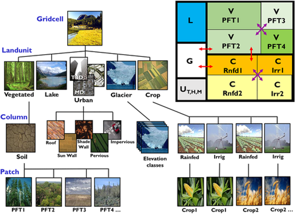 Figure 1: Schematic representation for Sub grid level heterogeneity of land surface and hierarchy in clm5 for classification of land
properties. The classification tree demonstrates how a grid cell is further delineated into different sub classes and box on the top
shows division of grid cell where V means vegetated, U means urban, C means crop, G: glacier, L: lake etc.(Lawrence et al., 2019)
https://agupubs.onlinelibrary.wiley.com/doi/full/10.1029/2018MS001583
Figure 1: Schematic representation for Sub grid level heterogeneity of land surface and hierarchy in clm5 for classification of land
properties. The classification tree demonstrates how a grid cell is further delineated into different sub classes and box on the top
shows division of grid cell where V means vegetated, U means urban, C means crop, G: glacier, L: lake etc.(Lawrence et al., 2019)
https://agupubs.onlinelibrary.wiley.com/doi/full/10.1029/2018MS001583
Model Description:
The Community Land Model (CLM5) is the version 5 default land component of
CESM2(http://www.cesm.ucar.edu/models/cesm2/ ) that represents land surface spatial
heterogeneity in subgrid level (Lawrence et al., 2019). In this approach, each grid cell of land
surface consists of various units, column and patches based on surface features. The land units
represented are natural vegetation, lake, glacier, urban areas, crop land, wetlands, other water
bodies (as shown in figure 1). This means per grid cells is composed of fraction/percentage of land
surface with each property that exist in that location. The urban Representation based on urban
land parameterization Community Land Model Urban (CLMU) (Oleson and Feddema, 2019) that
simulates urban climate at urban scale. Urban areas are further classified by this parameterization
into three classes that are tall building urban areas (TBD), high density (HD) urban areas and
medium density urban areas (MD). CLMU classifies these urban unit further into different urban
surfaces: building walls, impervious surface, roofs, urban vegetated surface, streets etc. which are
in scale of an urban canyon (Oke et al., 2017, Lawrence et al., 2019).
CLMU is responsible for carrying out calculation for any surface energy fluxes, physical
interaction, hydrological interaction between urban land surface and the atmosphere. Any changes
in urban surface features for example albedo, heat flux from building, increase in impervious road,
urban vegetation etc. directly modifies the surface flux into the atmosphere and properties such as
sensible heat, ground heat, near surface air temperature, reflected and absorbed longwave by the
surface and many more variables. The human influenced factor such as waste heat from buildings,
anthropogenic fluxes exchange from built-up surface are integrated into the model by using
building energy model that computes on detailed representation at a building scale (Oleson and
Feddema, 2020).
Experimental Design and Setup:
Run
fsurdat
Urban % Change
Mask/region
Control
Default fsurdat
No change
Baseline
Exp1
surfdata_modified10PCT.nc
+10% urban
Eastern U.S.
Exp2
surfdata_modified50PCT.nc
+50% urban
Same region
This project used CESM 2.1.5 to carry out Land_only sensitivity of thermal land and atmospheric
variables such as sensible heat flux from ground (FSH), Ground Temperature (TG), 2m air
Temperature (TSA), and internal urban building energy to change in prescribed land surface
dataset in CLM. In this experiment, atmosphere is uncoupled meaning no feedback from
atmosphere is feeding back in reproducing land surface data. The simulations were executed for
10-year spin-up using Satellite Phenology (SP) and land-only compset “l2000clm50Sp” (Li et al.,
2022) with initialization time 2000. The control run included default prescribed surface data file
and initialization period to simulate monthly output for sensible heat flux from ground (FSH),
Ground Temperature (TG), 2m air Temperature (TSA), and internal urban building energy (TBUILD). This simulation was run to compare against two other experiments with the changes
in static prescribed land surface data (as shown in the table 1 below). The resolution used for all
the runs is f09_g17 (1° 𝑎𝑡𝑚𝑜𝑠𝑝ℎ𝑒𝑟𝑒, ~0.9° 𝑙𝑎𝑛𝑑) which is supported by given land compset
(available on https://docs.cesm.ucar.edu/models/cesm2/config/2.1.3/compsets.html ).
CLM simulates based on static parameters that is prescribed land surface input data which is used
during the initialization process. The “UrbanParamsType” is a module that is responsible for
reading the static land inputs prescribed before initialization (Sun et al.,2023). One of the static
land inputs read during initialization is ‘fsurdat’ that specifies static land surface properties such
as Urban fraction per grid cell in percentage (PCT_URBAN), vegetation fraction per grid cell in
percentage (PCT_NATVEG), cropped fraction in percentage (PCT_CROP), Soil types, sand/clay
fractions, vegetation cover and structure, urban density classes (TBD, HD, MD), land mask,
elevation, leaf area index and other land surface variables. Generally, in CESM each land unit
interacts with CAM separately, but this project looks at uncoupled runs.
The experiment setup to compare against baseline were executed modifying the urban land fraction
which is represented by PCT_URBAN in ‘fsurdat’, surface data file. Each experiment was
modified adding extra urban land surface and decreasing vegetated land surface so that increase in
one land surface per grid cell could be balanced out by decrease in other land surface properties in
that grid cell. The two experiments were carried out adding 10% and 50% more PCT_URBAN to
all urban density classes: TBD, MD and HD while decreasing vegetated surface, PCT_NATVEG
by the same amount (see figure 2 below). This study intended to apply the changes over urban land
units of eastern CONUS and explore what response this change would trigger on thermal
parameter of land and atmosphere. The representation of total urban land unit (TBD+HD+MD)
default and after changes is shown in the figure 2 below. Simulations were submitted to reproduce
monthly output variables for 10 years after the initialization period with changes in static
prescribed variables.
 Figure 2:a) PCT_URBAN in default fsurdat file over eastern US before any changes, b) PCT_urban after +50% changes and c)
difference between before and after changes, d) PCT_NATVEG in default fsurdat file over eastern US before any changes, e)
PCT_NATVEG after decreasing by the same amount the PCT_URBAN increased per grid cell, f) difference in PCT_NATVEG
before and after
Figure 2:a) PCT_URBAN in default fsurdat file over eastern US before any changes, b) PCT_urban after +50% changes and c)
difference between before and after changes, d) PCT_NATVEG in default fsurdat file over eastern US before any changes, e)
PCT_NATVEG after decreasing by the same amount the PCT_URBAN increased per grid cell, f) difference in PCT_NATVEG
before and after
Results:
The monthly climatological differences in sensible heat from the ground (FSH) (W/m²) between
the control run and the +50% PCT_URBAN experiment revealed some interesting results,
particularly in certain regions of South Asia and the Tibetan Plateau throughout all months (Figure
3). These areas consistently exhibited a higher difference in sensible heat from the ground. This
observation suggests that the increase in urban land fraction may have significantly impacted South
Asia and the Tibetan Plateau. The results indicate that although urban land changes were applied
to unintended regions than Eastern CONUS, the surface variable, namely sensible heat, increased
and responded positively in those specific areas.
Certain areas in South Asia, specifically over the Indo-Gangetic Plain, showed a significant
increase in sensible heat, with an increase of up to +3 W/m² in June climatology (figure 4a). This
increase is attributed to the rise in urban land fraction per grid cell. In contrast, during August
climatology, the increased urban land fraction resulted in a rise of up to +1.2 W/m² in sensible heat
from the ground in some parts of northern China (figure 4c).
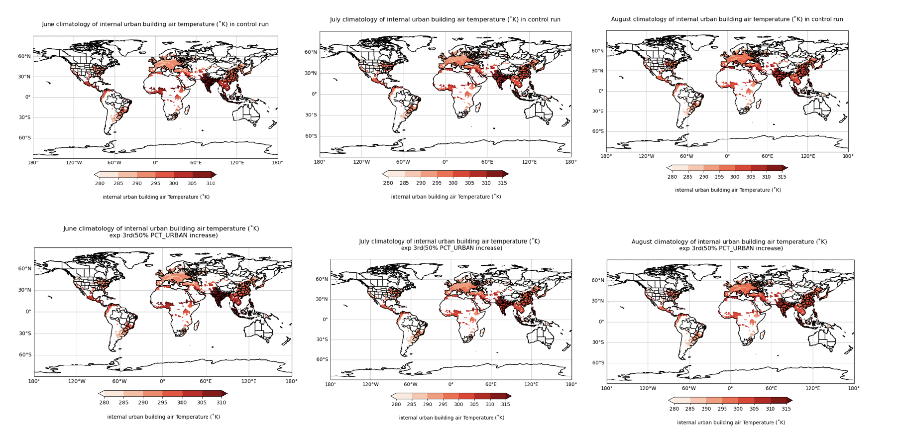
An increase in internal urban building air temperature (K) in response to changes in urban land
cover can consistently be observed across the same Asian regions for all-month climatology,
although the feedback is relatively small, approximately +0.13 K (Figure 5). This indicates that
indoor air temperature (T_BUILD) is still affected by an increase in urban land area within the
grid cell of the CESM urban representation, even if the effect is minor. T_BUILD increases for all
summer seasons, reaching +0.17 K above the control run for June climatology (Figure 5).
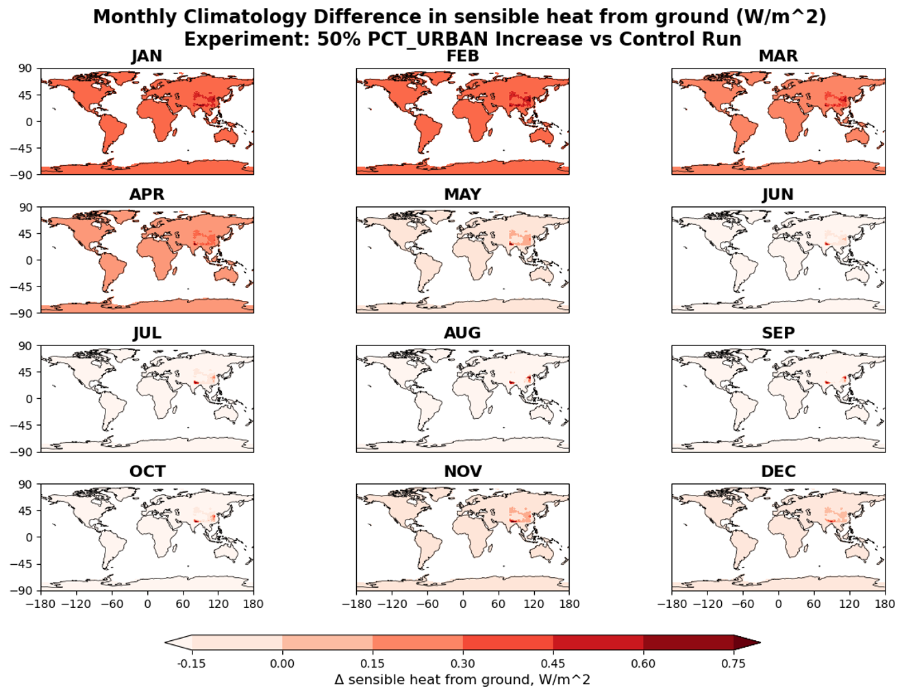 Figure 3: Sensible heat from ground (W/m^2) monthly climatological difference between control run and +50% increase in urban
land fraction per grid cell
Figure 3: Sensible heat from ground (W/m^2) monthly climatological difference between control run and +50% increase in urban
land fraction per grid cell
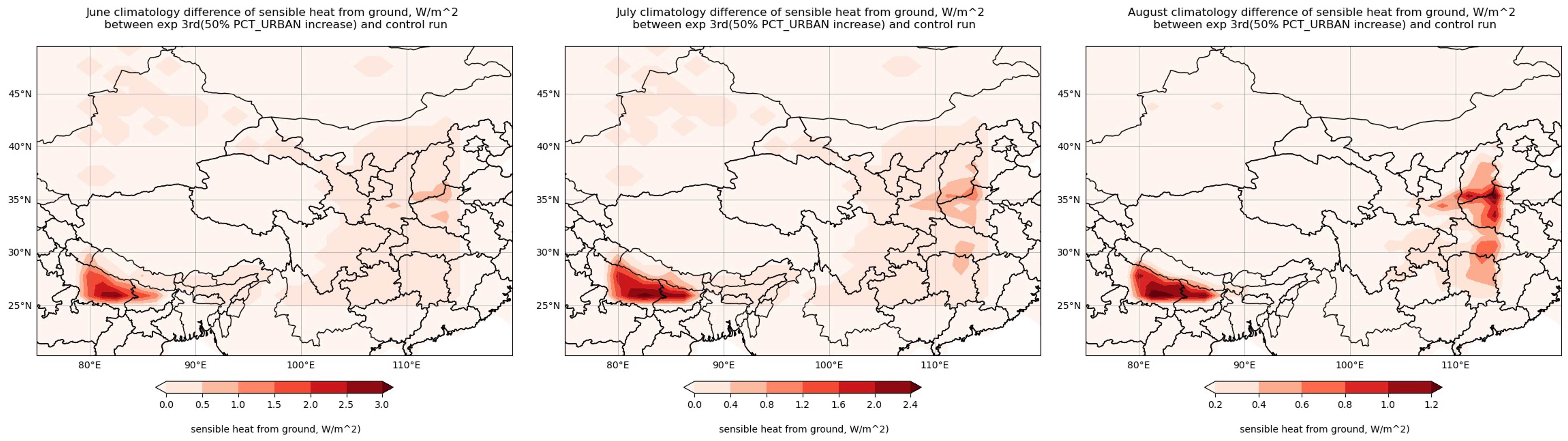 Figure 4: June, July and august climatological differences of sensible heat from ground calculated from control experiment minus
the +50% Urban_PCT run
Figure 4: June, July and august climatological differences of sensible heat from ground calculated from control experiment minus
the +50% Urban_PCT run
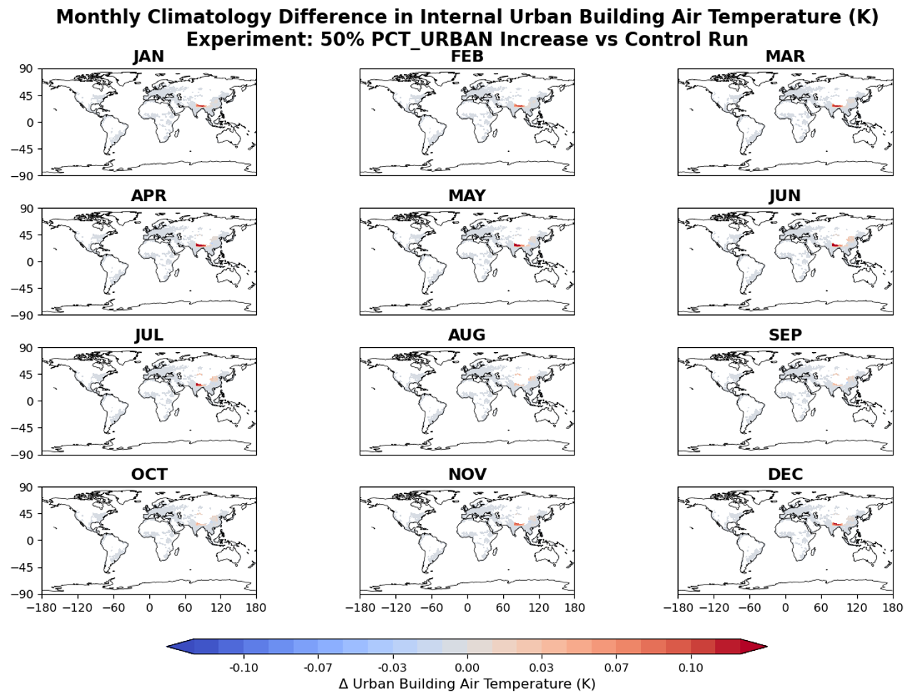 Figure 5: Difference between monthly climatology of internal urban building air temperature (Kelvin) between control run minus
+50% increase in Urban_PCT experiment
Figure 5: Difference between monthly climatology of internal urban building air temperature (Kelvin) between control run minus
+50% increase in Urban_PCT experiment
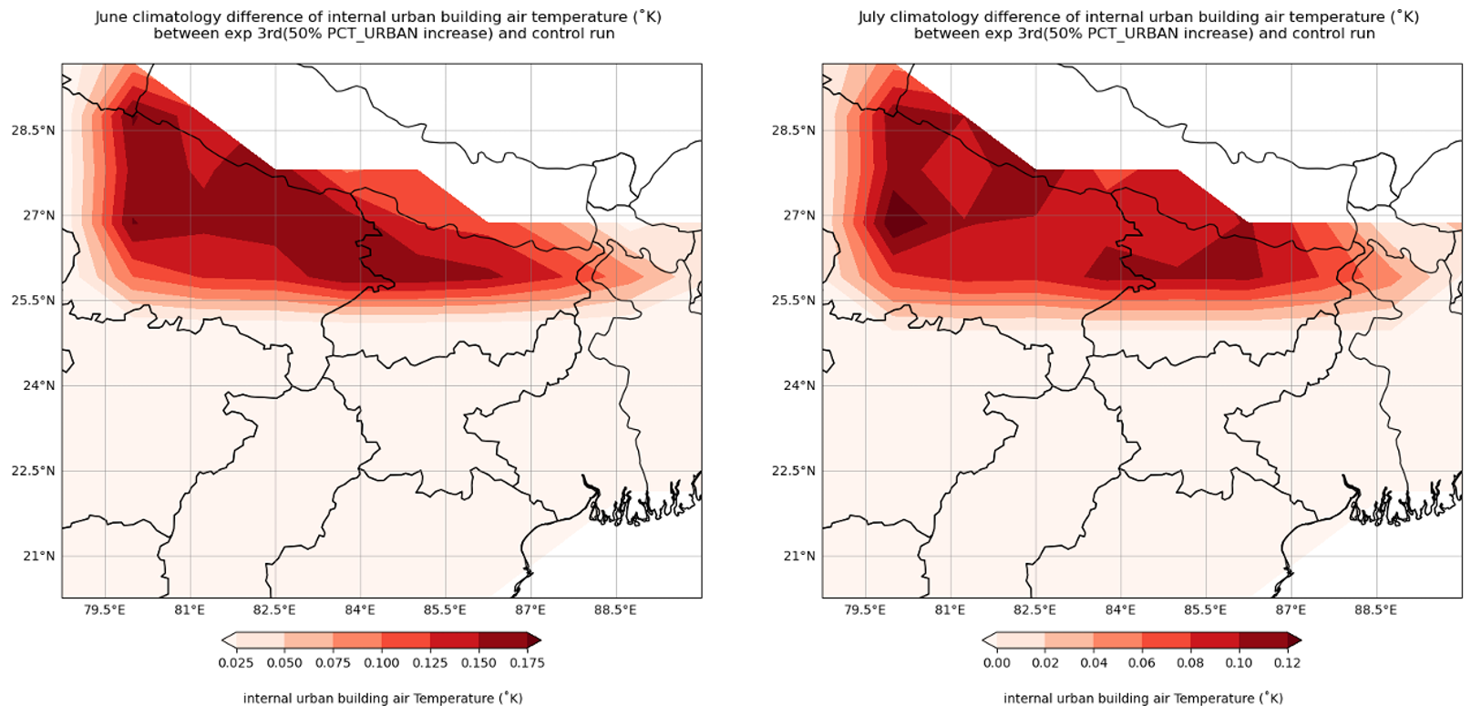 Figure 6: South Asian region areas where comparatively significant changes were observed
Notably, these regions exhibit the highest internal urban building air temperatures in the control
run compared to other areas (see figure in the supplemental material), which may have been
exacerbated by the increase in urban land fraction. Furthermore, the monthly climatology shows a
greater difference in Ground Temperature (TG, in Kelvin) for areas with a +50% urban percentage,
indicating a significant increase in these same regions (see figure for the difference in TG). This
confirms that the intended modifications for the Eastern CONUS region have been instead applied
to these parts of the Asian continent while updating the 'fsurdat' file. However, the +50% only
trigger insignificant changes ~ +0.07 kelvin (figure 7) for TG while just ~0.03 k for 2m air
temperature (figure 8).
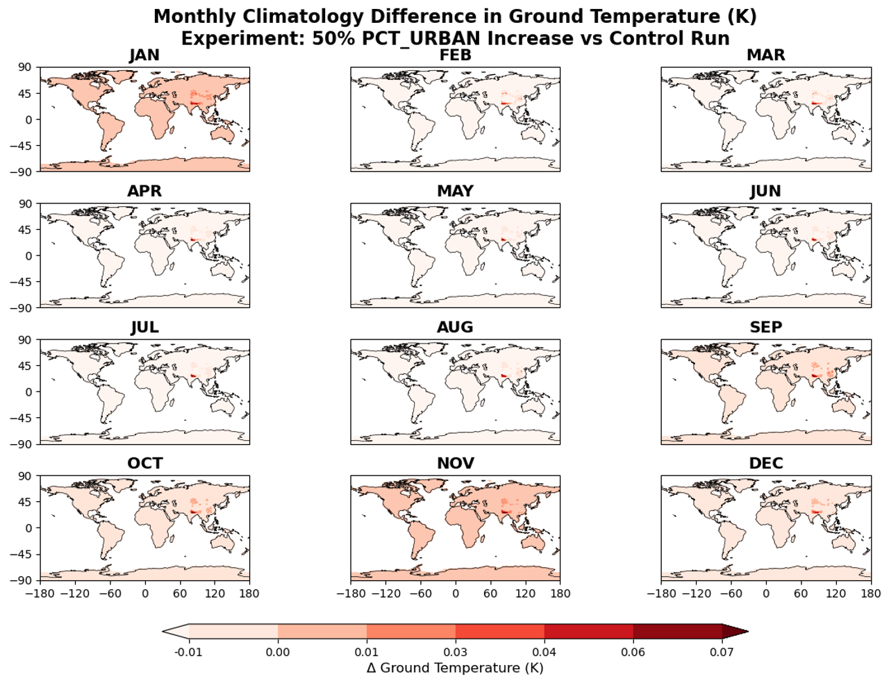 Figure 7: Difference between monthly climatology of Ground temperature (Kelvin) between control run minus +50% increase in
Urban_PCT experiment.
Figure 7: Difference between monthly climatology of Ground temperature (Kelvin) between control run minus +50% increase in
Urban_PCT experiment.
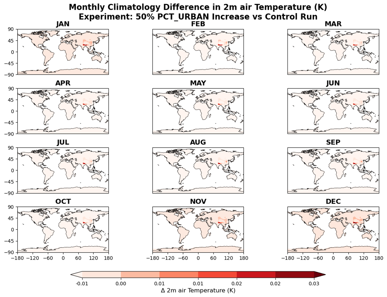 Figure 8: Difference between monthly climatology of 2m air temperature (Kelvin) between control run minus +50% increase in
Urban_PCT experiment.
Figure 8: Difference between monthly climatology of 2m air temperature (Kelvin) between control run minus +50% increase in
Urban_PCT experiment.
Exploring the response of ground temperature (TG), sensible heat from the ground (FSH), 2-meter
air temperature (TSA), and internal urban building temperature (TBUILD (waste heat from
building air conditioning) revealed varied impacts in relation to changes in urban land fraction.
Among all these thermal parameters, sensible heat from the ground exhibited a significant
response, while the others showed only minor increases, still indicating some sensitivity. Overall,
this suggests that the Community Earth System Model (CESM) with the Community Land Model
(CLM) version 5.0 is sensitive to surface data and changes in urban land use, even without
atmospheric coupling or active feedback mechanisms. Notably, a modest 10% increase in the
urban land fraction (PCT_URBAN) did not trigger any significant changes, indicating that CESM
does not demonstrate sensitivity to such a small alteration in urban area. Although these changes
in thermal meteorological variables are relatively minor, the findings imply that urbanization
affects ground temperature, sensible heat flux from impervious surfaces, and internal building
temperatures.
One limitation of this study is that the masking was applied to unintended regions, specifically the
Indo-Gangetic Plain in South Asia, some portion of East Asia particularly the Tibetan Plateau,
rather than focusing on the Eastern CONUS (Continental United States). The choice of where to
apply the increase in urban land fraction per grid cell is important because sensitivity can be
amplified if the selected grid cell or region already has an urban fraction.
In future studies, it would be beneficial to apply the increment specifically to areas that are already
urbanized, rather than to unurbanized regions. This approach can enhance the magnitude of
sensitivity, making it more meaningful for analyzing the thermal response to changes in land
surface properties. Additionally, incorporating atmospheric feedback through a fully coupled
model can improve the experiment and lead to more practical simulations. Such Experiments can
be crucial to understand potential future climate scenarios under expanding urban footprints.
References
-
Lawrence, D. M., Fisher, R. A., Koven, C. D., Oleson, K. W., Swenson, S. C., Bonan, G., Collier, N.,
Ghimire, B., van Kampenhout, L., Kennedy, D., Kluzek, E., Lawrence, P. J., Li, F., Li, H., Lombardozzi, D.,
Riley, W. J., Sacks, W. J., Shi, M., Vertenstein, M., … Zeng, X. (2019).
The Community Land Model Version 5: Description of New Features, Benchmarking, and Impact of Forcing Uncertainty.
Journal of Advances in Modeling Earth Systems, 11(12), 4245–4287.
https://doi.org/10.1029/2018MS001583
-
Oke, T. R., Mills, G., Christen, A., & Voogt, J. A. (2017).
Urban Climates. Cambridge University Press.
-
Oleson, K. W., Monaghan, A., Wilhelmi, O., Barlage, M., Brunsell, N., Feddema, J., ... & Steinhoff, D. F. (2015).
Interactions between urbanization, heat stress, and climate change.
Climatic Change, 129, 525-541.
-
Oleson, K. W., & Feddema, J. (2020).
Parameterization and Surface Data Improvements and New Capabilities for the Community Land Model Urban (CLMU).
Journal of Advances in Modeling Earth Systems, 12(2), e2018MS001586.
https://doi.org/10.1029/2018MS001586
-
Qian, Y., Chakraborty, T. C., Li, J., Li, D., He, C., Sarangi, C., Chen, F., Yang, X., & Leung, L. R. (2022).
Urbanization Impact on Regional Climate and Extreme Weather: Current Understanding, Uncertainties, and Future Research Directions.
Advances in Atmospheric Sciences, 39(6), 819–860.
https://doi.org/10.1007/s00376-021-1371-9
-
Sun, Y., Fang, B., Oleson, K. W., Zhao, L., Topping, D. O., Schultz, D. M., & Zheng, Z. (2024).
Improving Urban Climate Adaptation Modeling in the Community Earth System Model (CESM) Through Transient Urban Surface Albedo Representation.
Journal of Advances in Modeling Earth Systems, 16(12), e2024MS004380.
https://doi.org/10.1029/2024MS004380
Materials and Methods:
Model Description:
The Community Land Model (CLM5) is the version 5 default land component of CESM2(http://www.cesm.ucar.edu/models/cesm2/ ) that represents land surface spatial heterogeneity in subgrid level (Lawrence et al., 2019). In this approach, each grid cell of land surface consists of various units, column and patches based on surface features. The land units represented are natural vegetation, lake, glacier, urban areas, crop land, wetlands, other water bodies (as shown in figure 1). This means per grid cells is composed of fraction/percentage of land surface with each property that exist in that location. The urban Representation based on urban land parameterization Community Land Model Urban (CLMU) (Oleson and Feddema, 2019) that simulates urban climate at urban scale. Urban areas are further classified by this parameterization into three classes that are tall building urban areas (TBD), high density (HD) urban areas and medium density urban areas (MD). CLMU classifies these urban unit further into different urban surfaces: building walls, impervious surface, roofs, urban vegetated surface, streets etc. which are in scale of an urban canyon (Oke et al., 2017, Lawrence et al., 2019).
CLMU is responsible for carrying out calculation for any surface energy fluxes, physical interaction, hydrological interaction between urban land surface and the atmosphere. Any changes in urban surface features for example albedo, heat flux from building, increase in impervious road, urban vegetation etc. directly modifies the surface flux into the atmosphere and properties such as sensible heat, ground heat, near surface air temperature, reflected and absorbed longwave by the surface and many more variables. The human influenced factor such as waste heat from buildings, anthropogenic fluxes exchange from built-up surface are integrated into the model by using building energy model that computes on detailed representation at a building scale (Oleson and Feddema, 2020).
Experimental Design and Setup:
| Run | fsurdat | Urban % Change | Mask/region |
|---|---|---|---|
| Control | Default fsurdat | No change | Baseline |
| Exp1 | surfdata_modified10PCT.nc | +10% urban | Eastern U.S. |
| Exp2 | surfdata_modified50PCT.nc | +50% urban | Same region |
This project used CESM 2.1.5 to carry out Land_only sensitivity of thermal land and atmospheric variables such as sensible heat flux from ground (FSH), Ground Temperature (TG), 2m air Temperature (TSA), and internal urban building energy to change in prescribed land surface dataset in CLM. In this experiment, atmosphere is uncoupled meaning no feedback from atmosphere is feeding back in reproducing land surface data. The simulations were executed for 10-year spin-up using Satellite Phenology (SP) and land-only compset “l2000clm50Sp” (Li et al., 2022) with initialization time 2000. The control run included default prescribed surface data file and initialization period to simulate monthly output for sensible heat flux from ground (FSH), Ground Temperature (TG), 2m air Temperature (TSA), and internal urban building energy (TBUILD). This simulation was run to compare against two other experiments with the changes in static prescribed land surface data (as shown in the table 1 below). The resolution used for all the runs is f09_g17 (1° 𝑎𝑡𝑚𝑜𝑠𝑝ℎ𝑒𝑟𝑒, ~0.9° 𝑙𝑎𝑛𝑑) which is supported by given land compset (available on https://docs.cesm.ucar.edu/models/cesm2/config/2.1.3/compsets.html ).
CLM simulates based on static parameters that is prescribed land surface input data which is used during the initialization process. The “UrbanParamsType” is a module that is responsible for reading the static land inputs prescribed before initialization (Sun et al.,2023). One of the static land inputs read during initialization is ‘fsurdat’ that specifies static land surface properties such as Urban fraction per grid cell in percentage (PCT_URBAN), vegetation fraction per grid cell in percentage (PCT_NATVEG), cropped fraction in percentage (PCT_CROP), Soil types, sand/clay fractions, vegetation cover and structure, urban density classes (TBD, HD, MD), land mask, elevation, leaf area index and other land surface variables. Generally, in CESM each land unit interacts with CAM separately, but this project looks at uncoupled runs.
The experiment setup to compare against baseline were executed modifying the urban land fraction which is represented by PCT_URBAN in ‘fsurdat’, surface data file. Each experiment was modified adding extra urban land surface and decreasing vegetated land surface so that increase in one land surface per grid cell could be balanced out by decrease in other land surface properties in that grid cell. The two experiments were carried out adding 10% and 50% more PCT_URBAN to all urban density classes: TBD, MD and HD while decreasing vegetated surface, PCT_NATVEG by the same amount (see figure 2 below). This study intended to apply the changes over urban land units of eastern CONUS and explore what response this change would trigger on thermal parameter of land and atmosphere. The representation of total urban land unit (TBD+HD+MD) default and after changes is shown in the figure 2 below. Simulations were submitted to reproduce monthly output variables for 10 years after the initialization period with changes in static prescribed variables.
Results:
The monthly climatological differences in sensible heat from the ground (FSH) (W/m²) between the control run and the +50% PCT_URBAN experiment revealed some interesting results, particularly in certain regions of South Asia and the Tibetan Plateau throughout all months (Figure 3). These areas consistently exhibited a higher difference in sensible heat from the ground. This observation suggests that the increase in urban land fraction may have significantly impacted South Asia and the Tibetan Plateau. The results indicate that although urban land changes were applied to unintended regions than Eastern CONUS, the surface variable, namely sensible heat, increased and responded positively in those specific areas.
Certain areas in South Asia, specifically over the Indo-Gangetic Plain, showed a significant increase in sensible heat, with an increase of up to +3 W/m² in June climatology (figure 4a). This increase is attributed to the rise in urban land fraction per grid cell. In contrast, during August climatology, the increased urban land fraction resulted in a rise of up to +1.2 W/m² in sensible heat from the ground in some parts of northern China (figure 4c).
An increase in internal urban building air temperature (K) in response to changes in urban land cover can consistently be observed across the same Asian regions for all-month climatology, although the feedback is relatively small, approximately +0.13 K (Figure 5). This indicates that indoor air temperature (T_BUILD) is still affected by an increase in urban land area within the grid cell of the CESM urban representation, even if the effect is minor. T_BUILD increases for all summer seasons, reaching +0.17 K above the control run for June climatology (Figure 5).
Notably, these regions exhibit the highest internal urban building air temperatures in the control run compared to other areas (see figure in the supplemental material), which may have been exacerbated by the increase in urban land fraction. Furthermore, the monthly climatology shows a greater difference in Ground Temperature (TG, in Kelvin) for areas with a +50% urban percentage, indicating a significant increase in these same regions (see figure for the difference in TG). This confirms that the intended modifications for the Eastern CONUS region have been instead applied to these parts of the Asian continent while updating the 'fsurdat' file. However, the +50% only trigger insignificant changes ~ +0.07 kelvin (figure 7) for TG while just ~0.03 k for 2m air temperature (figure 8).
Exploring the response of ground temperature (TG), sensible heat from the ground (FSH), 2-meter air temperature (TSA), and internal urban building temperature (TBUILD (waste heat from building air conditioning) revealed varied impacts in relation to changes in urban land fraction. Among all these thermal parameters, sensible heat from the ground exhibited a significant response, while the others showed only minor increases, still indicating some sensitivity. Overall, this suggests that the Community Earth System Model (CESM) with the Community Land Model (CLM) version 5.0 is sensitive to surface data and changes in urban land use, even without atmospheric coupling or active feedback mechanisms. Notably, a modest 10% increase in the urban land fraction (PCT_URBAN) did not trigger any significant changes, indicating that CESM does not demonstrate sensitivity to such a small alteration in urban area. Although these changes in thermal meteorological variables are relatively minor, the findings imply that urbanization affects ground temperature, sensible heat flux from impervious surfaces, and internal building temperatures.
One limitation of this study is that the masking was applied to unintended regions, specifically the Indo-Gangetic Plain in South Asia, some portion of East Asia particularly the Tibetan Plateau, rather than focusing on the Eastern CONUS (Continental United States). The choice of where to apply the increase in urban land fraction per grid cell is important because sensitivity can be amplified if the selected grid cell or region already has an urban fraction.
In future studies, it would be beneficial to apply the increment specifically to areas that are already urbanized, rather than to unurbanized regions. This approach can enhance the magnitude of sensitivity, making it more meaningful for analyzing the thermal response to changes in land surface properties. Additionally, incorporating atmospheric feedback through a fully coupled model can improve the experiment and lead to more practical simulations. Such Experiments can be crucial to understand potential future climate scenarios under expanding urban footprints.
References
- Lawrence, D. M., Fisher, R. A., Koven, C. D., Oleson, K. W., Swenson, S. C., Bonan, G., Collier, N., Ghimire, B., van Kampenhout, L., Kennedy, D., Kluzek, E., Lawrence, P. J., Li, F., Li, H., Lombardozzi, D., Riley, W. J., Sacks, W. J., Shi, M., Vertenstein, M., … Zeng, X. (2019). The Community Land Model Version 5: Description of New Features, Benchmarking, and Impact of Forcing Uncertainty. Journal of Advances in Modeling Earth Systems, 11(12), 4245–4287. https://doi.org/10.1029/2018MS001583
- Oke, T. R., Mills, G., Christen, A., & Voogt, J. A. (2017). Urban Climates. Cambridge University Press.
- Oleson, K. W., Monaghan, A., Wilhelmi, O., Barlage, M., Brunsell, N., Feddema, J., ... & Steinhoff, D. F. (2015). Interactions between urbanization, heat stress, and climate change. Climatic Change, 129, 525-541.
- Oleson, K. W., & Feddema, J. (2020). Parameterization and Surface Data Improvements and New Capabilities for the Community Land Model Urban (CLMU). Journal of Advances in Modeling Earth Systems, 12(2), e2018MS001586. https://doi.org/10.1029/2018MS001586
- Qian, Y., Chakraborty, T. C., Li, J., Li, D., He, C., Sarangi, C., Chen, F., Yang, X., & Leung, L. R. (2022). Urbanization Impact on Regional Climate and Extreme Weather: Current Understanding, Uncertainties, and Future Research Directions. Advances in Atmospheric Sciences, 39(6), 819–860. https://doi.org/10.1007/s00376-021-1371-9
- Sun, Y., Fang, B., Oleson, K. W., Zhao, L., Topping, D. O., Schultz, D. M., & Zheng, Z. (2024). Improving Urban Climate Adaptation Modeling in the Community Earth System Model (CESM) Through Transient Urban Surface Albedo Representation. Journal of Advances in Modeling Earth Systems, 16(12), e2024MS004380. https://doi.org/10.1029/2024MS004380